Rosal’s winds have reached 195 km/h, with heavy rain, strong gusts and hazardous seas forecast across parts of the Philippines.

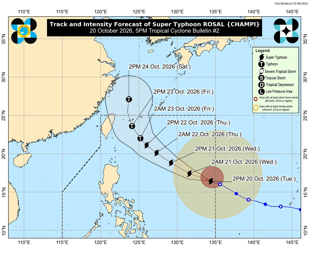
Super Typhoon Rosal is gaining strength over the Philippine Sea, and its broad reach is bringing wind and sea hazards to parts of the Philippines even though PAGASA does not expect it to make landfall. The storm’s maximum sustained winds climbed to 195 kilometers per hour on Tuesday afternoon, October 20, while gusts rose to 240 km/h, the weather bureau reported at 5 pm.
Rosal, also known as Champi, was located 1,270 kilometers east of Central Luzon at 4 pm, moving west northwest at 25 km/h. It entered the Philippine Area of Responsibility at 10:40 am. PAGASA expects the storm to pass closest to extreme Northern Luzon from Thursday, October 22, through Friday, October 23.
Rain and wind risks extend beyond the storm’s track
Rosal’s trough may bring scattered rain and thunderstorms to more areas on Tuesday evening, including the whole of Bicol and Eastern Visayas. Farther north, PAGASA forecasts the heaviest rainfall in Batanes and Cagayan over the 24 hours from Thursday afternoon to Friday afternoon:
- Heavy to intense rain, 100–200 millimeters: Batanes
- Moderate to heavy rain, 50–100 mm: Cagayan
For now, Batanes, Ilocos Norte and the Babuyan Islands are expected to receive only isolated light rain from the northeasterly windflow.
As of Tuesday’s 5 pm bulletin, Signal No. 1 covered the following areas, where residents should prepare for strong winds:
- Batanes
- Babuyan Islands
- Northern Ilocos Norte, including Pagudpud
- Northern and eastern mainland Cagayan: Santa Ana, Gonzaga, Lal-lo, Santa Teresita, Camalaniugan, Aparri, Buguey, Gattaran, Baggao, Peñablanca, Santa Praxedes, Claveria, Sanchez-Mira, Pamplona, Ballesteros, Abulug and Allacapan
- Northeastern Isabela: Maconacon, Divilacan and Palanan
- Northeastern Catanduanes: Pandan, Bagamanoc, Panganiban, Viga and Gigmoto
PAGASA said the highest possible tropical cyclone wind signal from Rosal is Signal No. 2 or 3. The storm’s outer bands, combined with the northeasterly windflow, are also expected to generate strong to gale-force gusts across a wider area.
- Tuesday, October 20: Batanes, Ilocos Norte, Cagayan, Isabela, Polillo Islands, Camarines Norte, Camarines Sur, Catanduanes, Northern Samar, Eastern Samar, most of Caraga, Camiguin, Misamis Oriental, Sarangani, Davao del Sur and Davao Occidental
- Wednesday, October 21: Ilocos Region, Cordillera Administrative Region, Cagayan Valley, Polillo Islands, Bicol, Romblon, Eastern Visayas, Iloilo, Guimaras, Negros Occidental, Siquijor, Bohol, Northern Mindanao, Caraga, Davao Region, Sarangani and Zamboanga del Norte
- Thursday, October 22: most of the country
Sea conditions are forecast to worsen gradually along exposed coasts. PAGASA’s outlook for the next 24 hours calls for:
Very rough seas, with waves up to 4.5 meters. Travel is risky for all vessels.
- Northern and eastern Catanduanes; Isabela’s seaboard; northeastern mainland Cagayan; southeastern Batanes; northeastern Babuyan Islands
Rough seas, with small vessels advised to stay in port.
- Waves up to 4 meters: northern and eastern Batanes; the remaining eastern coasts of the Babuyan Islands and mainland Cagayan; northern Camarines Norte and Camarines Sur; northern and eastern Northern Samar and Eastern Samar; eastern Albay and Sorsogon
- Waves up to 3.5 meters: northern and eastern Polillo Islands; northern Aurora; remaining Batanes coasts
- Waves up to 3 meters: northern Quezon; eastern Dinagat Islands and Siargao-Bucas Grande Island Group; remaining coasts of Cagayan, Aurora and Camarines Norte
Moderate to rough seas, with small vessels advised to take precautions or avoid sailing where possible.
- Waves up to 2.5 meters: Surigao del Sur, Surigao del Norte and Davao Occidental coasts; eastern Davao Oriental; northern and eastern Quezon; remaining Catanduanes coast
- Waves up to 2 meters: Ilocos Norte and Ilocos Sur; southern Davao Oriental; remaining northern and eastern Camarines Sur; remaining coasts of Polillo Islands, Dinagat Islands and Siargao-Bucas Grande Island Group
ALSO ON RAPPLER
- After lower budget in House version, DepEd asks Senate for P147 billion more
- [Vantage Point] The price of control: Behind Metro Pacific’s P12.4-B Meralco bet
- Adamson’s strong start surprises Nash Racela, adds to La Salle’s woes
Forecast track and seasonal context
PAGASA expects Rosal to continue generally west northwest through Wednesday, October 21, then turn northwest until Friday morning. It may shift north northwest to north from Friday afternoon, leaving the Philippine Area of Responsibility by Friday evening or early Saturday morning, October 24.
The bureau sees a chance of further strengthening over the Philippine Sea in the coming hours. It also forecasts that Rosal could weaken to typhoon intensity on Thursday evening or early Friday morning.
Rosal is the Philippines’ 18th tropical cyclone of 2026 and the first recorded in October. PAGASA had projected one or two cyclones for the month.
The country is shifting into the northeast monsoon, or amihan, after the end of the southwest monsoon, known as habagat, announced on October 5. The transition usually brings colder spells, though the coming amihan period may be warmer: a strong El Niño in the tropical Pacific is forecast to become very strong in the fourth quarter of 2026. For Northern Luzon, the nearer-term concern is Rosal’s combination of heavy rain, gusty winds and hazardous seas as it passes offshore. – Rappler.com
Discussion
Sign in to join the discussion.